Hazardous Liquid HCA Projects
FreemanGIS is adept at building geospatial databases of high consequence area (HCA) resource information. Knowing the sensitive resources behind could affect HCAs:
- improves integrity management risk assessments and Emergency Flow Restrictor Device (EFRD) placement studies
- helps prioritize field investigation and pipeline repair work orders
- strengthens emergency response efforts
- enhances community relations
Some representative projects are:
Ecological USA Validation
Species occurrence data were collected for a 20-mile corridor that covered 11,000 miles of pipe and 13 states. The species data were tied back to ecological unusually sensitive areas (USAs) to assess whether the location, shape, sensitivity, and existence of the animal, insect, or plant had changed since the USAs were posted on the NPMS in 2001. The shape and location of ecological USAs were updated and invalid USAs were marked and documented with cause. New species occurrences in the corridor that met the USA criteria were marked as USA candidates, effectively providing the operator with a current refreshed view of ecological USAs near their pipeline.
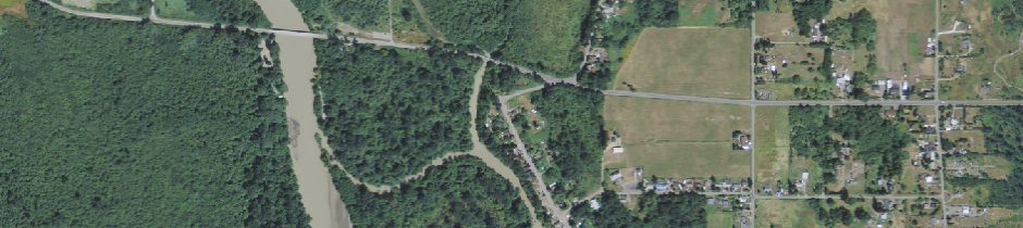
Operator-Identified Populated Areas
The populated areas on the NPMS come directly from Census Bureau data. The areas are drawn using Census Bureau definitions, which can change over time. Delineation criteria are not standardized at a nationwide or statewide level, as the rest of the HCAs are, nor are they designed for integrity management use. Thus populated area HCAs can capture large tracts of barren land, industrial zones, and extraterritorial jurisdictions while ignoring obvious areas of residential sprawl and small town communities.
Using a synchronized approach that involved air photo interpretation, current Census Bureau data, city limit and zoning maps, and internet research, FreemanGIS revised the NPMS populated areas along a 1000-mile pipeline to reflect where people actually live. Urban areas with new residential growth and small towns with clearly-defined street grids and viable populations were mapped as operator-identified populated areas. The updated information was used to revise one call notification areas and enhance the operator's integrity risk assessment and public awareness campaigns.
USA Resource Database Development
FreemanGIS investigated drinking water and ecological USAs identified as "could affect" by a pipeline operator to determine the resource at risk and verify accuracy. The effort required extensive data collection involving numerous rounds of communication with 27 government agencies across 10 states. Significant data conversion, assimilation, verification, and documentation were involved. The sensitive resource information was loaded into the operator's GIS database and linked back to each of the could affect USAs for ease in map display and query when re-assessing risk.